Traveling and hiking are a part of everyone's life. For some, a trip to a neighboring city is enough, others plan to cross the mountains, and the third group leaves for other countries. Certain professions are related to orienteering. These are pilots and sailors. In any case, everyone plans their trip in advance, draws up a route, and determines the pass points.
It becomes very unpleasant when a trip to the forest to pick mushrooms or just for the sake of adventure is overshadowed by wanderings and anxiety. In such a situation, a compass and maps come to the rescue. Having them at hand, you will get out of the unknown surroundings to civilization without much difficulty. It is important to understand what it is, what it is needed for and learn how to properly use a compass in the forest without a map.
How does a compass work?
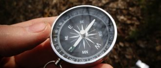
This is a small device, in the center of which an arrow is attached to a thin needle. It makes rotational movements exactly parallel to the Earth's force lines, which are surrounded by magnetic fields. The discovery is listed among the four most important and valuable achievements of Chinese scientists. In terms of its value, it can be compared with the invention of gunpowder, paper and textile printing. Modern models have been improved and have some variations. However, the principle of how to use the compass remains the same.
Let's take a closer look at how a compass works:
- The classic version is round. Mostly metal and plastic models are sold. They are not made of iron. They are made from copper and aluminum. Models with reinforced housings are also available.
- The dial is visible under the glass cover. Its second name is limbo . The designations of the sides of the horizon are recorded on it. Also, the division on the compass is indicated in ascending order - degrees. Zero on the compass is north, 90 is east on the compass, 180 is south, 270 is west. The countdown is clockwise.
- The compass needle is also located under the cover. It is placed on a thin pin to make the movement as easy and precise as possible. Often there is a two-color version, where the red arrow on the compass shows the north direction. However, compliance with such a rule falls only on the shoulders of the manufacturer.
- A lock is a mechanical locking lever designed to hold the arrow during non-working moments. When it descends, the compass needle is immediately freed and begins to seek north.
- The classic version is complemented by an outer ring designed to establish a movement reference. In modern models, the ring is replaced by a human-controlled arrow. Devices with a ruler and a map are also available. Sometimes they are supplemented with a magnifying glass.
Circle of Old Heavens
This circle has a second name - the primordial Bagua indicates the order of things in the Universe, describes the original world of Tao and the laws of existence. The energy of the Tao world is beyond time and space. It is everywhere: in things, objects. Feng Shui masters use this energy to influence the flow of earth energy.
The circle of the former heavens can tell about the order of things in the Universe. In this circle in the south is the sky (Qian), in the north - earth (Kun), in the east - fire (Li), in the northwest - mountain (Gen), in the west - water (Kan), in the northeast - thunder (Zhen), in the southeast - a body of water (Dui), in the southwest - wind-tree (Sun). Balance is achieved by opposing positions. Each pair contains three Yin traits and, similarly, three Yang traits.
Thanks to the circle of the former heavens, one can learn the order of things in the Universe by making a complete revolution in a circle. Moving clockwise from the trigram Zhen (thunder) to Qian (sky), you can see the changes that occur as Yin and Yang wax and wane.
Yang energy begins in the northeast, reaching its highest point in the south. This is indicated by three straight lines.
Yin energy begins in the southwest, in the zone of the trigram Sun (wind), reaching its highest point in the north. This means the dotted lines of the trigram Kun (earth).
During the birth of one energy, the other necessarily weakens, and this moment is considered the beginning of a new cycle.
There are other types of compass:
With magnetic needle. The compass is divided into two colors. North is indicated in red, and south is indicated in black. In addition to the arrow, there is a 360° rotating disc that can be installed manually. Some compasses use white for north and red for south.
When is a compass better than a navigator?
New gadgets are invented and released for sale every day. One of these fashionable devices is GPS navigators . It contains a map and route planning function. Communication with the satellite allows you to accurately determine the location of the traveler and accompanies him throughout the entire route.
The main disadvantage of this gadget is the battery. It may shrink or break unexpectedly. In this case, the tourist will not be able to obtain any data about his location.
The GPS navigator includes a map and route planning function.
It’s easier in this regard with a tourist compass and a geographical map. They do not depend on the battery capacity, and the needle readings are accurate in nature.
It is important to remember to keep the device away from electronics, magnets and metals. The only difficulty is knowing the rules for reading a map, the basics of drawing a route and the rules for using a compass.
If you participate in orienteering competitions, then you will definitely need:
- special sneakers with an aggressive tread and good foot support
- trousers - tights that cover the legs and prevent cuts to the shins on the tall grass
- powerful flashlights
- special backpacks for running
Good luck at your orienteering starts and interesting adventures!
New items at Kant:
- New collection of Hoka sneakers
- Warm "Arctic" for your adventures. Updated collection of thermoses and thermal mugs
- Updated Deuter Astro down sleeping bags. For the most extreme travels in comfort
- Ortlieb bags for cycling and bikepacking - in Kant!
We also recommend you useful articles:
- The best trekking routes in Crimea for the May holidays. Complete information and correct choice of equipment and clothing
- Volcanoes of Kamchatka and other amazing wonders. What else can you see in this stunning place?
- The right choice of mittens and gloves for freeride and mountaineering
- Deuter® is more than just backpacks. Environmental standards and social responsibility of the brand
- Urban backpacks: 10 best models
- Ski touring school in the Elbrus region. Results of personal participation in the program of the Mountain Club "Kanta"
- BUFF and mountains: review of the popular Mountain collection. What mountain peaks served as inspiration?
- Clothes for skiing in Krasnaya Polyana in spring. What to choose?
When purchasing, you can apply accumulated or welcome bonuses to your first purchase. To do this, you need to register in the new Kanta bonus program and receive welcome bonus rubles to your account just for registration.
And yes, we still have a “winter sale” with discounts of up to 70%.
Author: Karolina Dergunova
How to navigate with a compass
Move away from electronics and metal congestion. To begin orientation, you need to remove the arrow from the clamp. It will perform several rotational movements, stabilize and point north.
Once you know the direction, adjust your map exactly to the compass. Select some objects and compare what you see with your map.
Once you have determined your position, you need to determine your destination and create a route. To do this, compare the north of the map and your device, and indicate the direction.
Designations on the compass cardinal directions
The notation system uses the first letters. For example, Russian manufacturers often use N - north, S - south, E - east, W - west.
The international system assumes the use of the Latin alphabet: North (N - north), South (S - south), East (E - east), West (W - west).
This is a simplified version. It is acceptable to indicate intermediate values on the dial.
How to calculate cardinal directions
Looking at and studying the map in detail, we know that north is drawn at the top and south at the bottom. In this case, the location of the cardinal points can only be approximately calculated. With a compass, things are a little different. The compass needle is not fixed and does not indicate the location of your position and other objects on the map. It is required to identify cardinal directions.
The magnetized part of the rotating needle always points north. The second half is to the south. In various scientific publications there is often an indication that the northern part is blue. In other sources - red. In practice, it can even be multi-colored. To avoid errors, you must independently determine the magnetized half. This will further ensure that your compass is working properly.
To explore, go outside with your device at noon. Until 12.00 the sun is located near the southern direction. The half that faces the sun is south.
How to navigate by the sun and the clock is described in more detail in the article “How to navigate in the forest by the sun and the clock.”
How to find azimuth using a compass
Azimuth is the angle between north and your destination, measured in degrees.
Procedure to determine azimuth:
- Place the device horizontally.
- The arrow descends from the latch.
- When the needle stabilizes and stops oscillating, it is aligned with the C (S) value on the dial.
- Select your destination. Align with the degrees on the compass.
- Calculate the given angle and strictly follow it. Try not to deviate.
Following the data received, the tourist will accurately reach the goal. To return, a reverse azimuth is taken - you need to go in the opposite direction.
Determining compass position without a map
The compass also makes it possible not to get lost in an unfamiliar forest without a map. Choose an object that will become a guide for you. It is better if it is an extended object - a road or a river.
Then you need to move into the forest perpendicular to the selected object. At the same time, it must be visible to the traveler.
Avid hikers often purchase transparent compasses. They are much more convenient when working with maps, and the drawn lines and contours greatly simplify orientation with a compass on the ground.
Next, work with the compass begins. It is placed on a flat surface and the arrow is activated. As soon as the arrow stabilizes, it is compared with the north. Draw a mental line to the object. The fixed value is the return azimuth for return.
Note! When moving in a wooded area, it is important to monitor deviations from the chosen course and try to avoid them.
To return, you need to take the compass so that the front sight points directly ahead.
Orientation by compass and map
If you are planning a long trip, and your destination is located far from a city or village, then it would be a good idea to stock up on a map, compass, ruler and pencil, and learn how a compass works. Many travelers research the area in advance.
Procedure:
- Place the map strictly horizontally and mark all the places you plan to visit.
- Next, place the device on the card and activate the arrow.
- Align the northern half of the arrow with the same value on the geographic map.
- Using a ruler, draw a line between the first stop on the route sheet and the middle of the dial. Calculate the heading azimuth to the first selected point. It is recommended to immediately record the return azimuth in the records.
- Next, mark all the selected points in this way.
- When you hit the road, keep an eye on your data.
When planning stops at several points, all measurements are made in advance, since this will take up valuable time along the way.
Having made preliminary calculations, you can not be afraid of getting lost even in an unfamiliar or wooded area.
There are ways to determine cardinal directions by surrounding objects, for example, if you are in a forest
You can use them if necessary.
It is believed that tree rings are much wider in the south than in the north. Numerous observations have shown that the width of the rings depends on a number of factors, in particular also on the direction of the prevailing wind.
A slightly more reliable method of orientation is based on mosses and lichens, which are mainly concentrated on the northern side of the tree. But you should not focus on just one tree; you need to compare several trees. For orientation, you can and should use not only trees, but also stumps, large stones, and rocks. The bark of trees is usually rougher and darker on the northern side than on the southern side. This is especially noticeable on birch, pine, and aspen. But again, several trees should be compared. In the forest, especially after rain, it is clearly visible that the trunks of pine trees from the north are darker. In coniferous trees, resin deposits are much more abundant on the south side. In spring, the grass grows higher and thicker to the south from isolated trees, stones, and stumps, and on a hot day it remains greener and lush to the north from these objects.
In large forestry areas, the sides of the horizon can be determined by clearings, which, as a rule, are cut almost strictly in the north-south and east-west directions. This is very clearly visible on large-scale maps. On the same map you can see that not all of the indicated clearings maintain the north-south and east-west directions. Some of the clearings were cut in other directions (parallel to the highway, railway, or depending on the terrain, especially in mountainous areas). The forest is divided by clearings into quarters, which in our country are numbered, as a rule, from west to east and from north to south.
Anthills are located on the southern side of trees, stumps and bushes, the southern slope of the anthills is gentle, the northern slope is steep.
It has been noted that the southern slopes of mountains and hills are usually drier than the northern ones. If you look closely, the soil near large stones and stumps in the summer is more moist from the north of these objects than from the south.
Good topographical preparation and mastery of orienteering techniques allow solving tactical problems: confident movement along the route in compliance with the marching schedule and calendar plan. Systematic training plays a major role in improving topographical, tactical, and technical training. Taking part in orienteering, rogaining or forced marching will be useful practice.
Many people believe that a compass is a specific device and is necessary only for professional tourists and athletes. But it can be useful in any conditions: both on a hike and on vacation. It will help you navigate the area well and not get lost. To feel confident on vacation, you need to have a compass with you, which can come in handy at any moment.
All Silva compasses in Kant
Specifics of using compasses
The principle of operation with some devices may be a little specific. First of all, it is necessary to select from the total mass those devices in which the arrow is glued to the dial. This greatly simplifies the task, because now you don’t have to combine the arrow and the north. Many tourists note the convenience of such a device. However, it is slightly slower than its simplified predecessor.
Another option is complemented by a small mirror. It is designed to control the measurements of the magnetic needle relative to the scale.
Avid tourists often purchase transparent ones. They are much more convenient when working with maps, and the drawn lines and contours greatly simplify orientation with a compass on the ground. Using it you can calculate the true azimuth. In this case, the work will not depend on nearby magnets, cars or electrical appliances.
Also in products for tourists you can find options with liquid in a flask. There are no differences in the functioning of devices with air.
Military, army or artillery models are distinguished as a separate category. They differ significantly from an amateur device. The military compass is made of impact-resistant material, and the needle stabilizes much more clearly and quickly. These two seemingly insignificant differences greatly simplify the work.
Compass error, magnetic declination
Geographic poles do not always coincide with magnetic poles. This phenomenon is associated with the laws of terrestrial magnetism and was discovered back in the 19th century. This fact has already been taken into account in electronic devices and on maps.
The north magnetic pole is located 700 miles from the geographic pole, while at the same time a deviation of 1,500 miles is recorded in the southern hemisphere. The difference, namely the angle formed between the indicators, is called magnetic declination.
The anomaly has been recorded in every part of our planet. For the most part, the differences are minor and do not require adjustment. In some areas the error can reach 25 degrees. To calculate the direction in this case, you must rely on information from the map.
Note! Due to the constant movement of the Earth and the displacement of layers, the values change. Therefore, it is recommended to update the maps periodically.
What to do if the compass does break?
The first thing a tourist needs to do is calm down. A breakdown even in unfamiliar surroundings is not a problem or a death sentence. This device can be easily built independently from scrap materials that an experienced tourist always has:
- sewing needle;
- bottom of a plastic bottle;
- a piece of tree bark or cork (about 3x3 cm in size);
- battery or magnet.
It is necessary to make a groove in a wooden cork or bark where the needle will later fit. The needle must be magnetized. This is done in one of 2 ways:
- One end is applied to a magnet, and the other is brought to a lit match. This is necessary to demagnetize the second half.
- Take a needle with insulated wire and attach different ends to different poles of the battery. That edge that touched the negative value will point to the north.
Next, the needle is placed in a groove, which in turn descends into the bottom of the lid with water. It will take some time. The improvised arrow will make several rotations and point north.
Recommendations for use
A compass is a device that requires testing for serviceability upon purchase. Particular attention should be paid to the speed of needle stabilization. When searching for the north for a relatively long time, it is better to abandon the device.
Having decided on the model, it is important to carefully study the attached instructions and learn how to use it. Further actions:
- Calibrate correctly.
- Practice: use the device in a familiar area.
- If the purchased device is electronic, buy a backup battery.
- When planning a route and determining the duration of a trip, you need to take into account the degree of energy consumption of an electrical appliance.
Important! With prolonged use, some parts of the compass may become slightly deformed. Therefore, it is recommended to periodically check the device for serviceability.
Types of compasses
When choosing a compass, you need to rely on your needs, goals and some fundamental points of their use.
Magnetic
This is the simplest and long-known device. Its second name is Adrianov, in honor of the name of the Russian engineer-inventor. It is made of a metal or plastic body. Inside this case there is a dial indicating the cardinal directions and degrees. The cardinal directions are determined by a magnetized arrow. It interacts with the Earth's magnetic field.
There may be ordinary air or water inside the case. Some models are equipped with a lock that holds the arrow while the compass is not in use. Magnetic is the most widespread device among experienced tourists and amateurs.
Electromagnetic
Electromagnetic ones are used in cars, airplanes and ships. The action is carried out due to magnetic induction.
Operation does not depend on nearby electrical appliances, metals or magnets. This feature allows you to calculate the route with the smallest error.
Electronic
Electronic is an achievement of modern technological progress. The principle of operation is similar to the navigator. The device is battery powered and receives the signal from the satellite. The technique takes into account all errors and magnetic declinations. That is, they are the most accurate.
The only drawback is the possibility of battery discharge, which prevents use on a long hike where there is no way to charge the gadget.
Gyroscopic
The functioning of the device is ensured by a gyroscope. This is a device that responds to changes in orientation angle. Most often, such models are found in shipping and rocketry.
How to use a military compass
Military models are considered to be the most accurate measuring instruments. The compass body is made of metal, which ensures shock resistance and reliability when carrying out important military assignments.
Another plus is that the case is sealed and waterproof. Some will not lose their qualities even at depth. However, you can also find non-sealed ones on sale - the choice depends on the conditions in which you will use the selected device. After all, even an experienced tourist may be interested in purchasing a military device. For a novice traveler, the difference will not be noticeable.
Military compass.
The principle of operation does not differ from the operation of a regular tourist one, but however, it is recommended to read the instructions in advance.
As an additional element, they have a built-in ruler to make working with maps easier. To take accurate measurements, some models are equipped with a magnifying loupe and a viewfinder. Such a device will help make accurate calculations and set the right course for further movement.
Long life, impact resistance, affordability, simplicity and ability to be used in a wide range of weather conditions make military a popular option among terrain navigation products.
Tips for choosing a convenient model
Due to the availability of a huge variety of compasses on sale, the question arises: which device to buy so that it is reliable, maximally functional, easy to use, and suitable for certain purposes.
For cars and motorcycles
For a motorcycle rally or car trip to unknown places, it is recommended to focus on electronic models of compasses. They guarantee accurate data. In addition, the operation of such devices will not be affected by metal parts of vehicles. This means that the functionality of the devices will not be affected. Recharging electrical appliances is done by using the energy of a running vehicle.
For bicycles
Cycling trips usually take place near populated areas. The best option in such cases would be a liquid compass. If you hang it on your wrist using a neck cord, you can constantly monitor your location without stopping your movement. When planning a bike ride to a remote city, it is better to take care of a spare electronic device.
A wrist compass is great for cyclists
For hiking
You can calmly walk around the territory of a huge nearby park using the simplest magnetic compass. If such walks take place with children, then it is recommended to purchase a children's model that is worn on the arm. In this way, the younger generation can be familiarized with the rules for using the device and instill orientation skills in the form of a game.
For sports
To practice orienteering, it is important to have special equipment. For such purposes, a liquid device is best suited. It is convenient, works quickly, and gives accurate readings.
Orienteering
Attention! As a general rule, competitors are prohibited from using electronic devices at orienteering competitions.
What to look for when choosing
When choosing a compass, it is important to be able to determine the most suitable device for yourself. Experienced travelers recommend focusing on:
- Case size and weight.
- Protection from moisture.
- Resistance to external mechanical influence.
- Availability of backlight.
- Functionality.
- The presence of a gyroscope, barometer, altimeter.
After analyzing the points described above and understanding the characteristics of a particular device, you can easily determine how suitable it is for use in specific conditions. With the right choice, a person will be able to easily determine the cardinal directions on a compass, which means he will not get lost and will quickly reach his tourist destination.
Principle of operation
In order to understand how to navigate with a compass, you need to know how it works and define the basic concepts. Magnetic field is the ability of the Earth's poles to influence electrical charges. Azimuth is the angle between two objects. N, S, E, W are standard compass marks indicating north, south, east and west.
The structure of a standard compass is elementary: a round base with a steel needle, at the end of which a magnetic pointer is attached. This model was invented by the Russian engineer Adrianov, and it is most often found due to its simplicity and ease of use. The pointer reacts to the planet's magnetic field and turns toward the poles.
Using a compass requires knowledge of the cardinal directions. The blue arrow tip always points north. In addition to the letter designations, the dial also has a degree scale. The standard division step is 10 degrees. The electronic navigator makes location calculations and displays information on the display.